Industrial Field Intelligence
Field intelligence for safer oilfield operations.
StrataIntel helps oil and gas operators and service companies reduce field uncertainty before excavation, construction, maintenance, inspection, or operational intervention.
Field data workflow
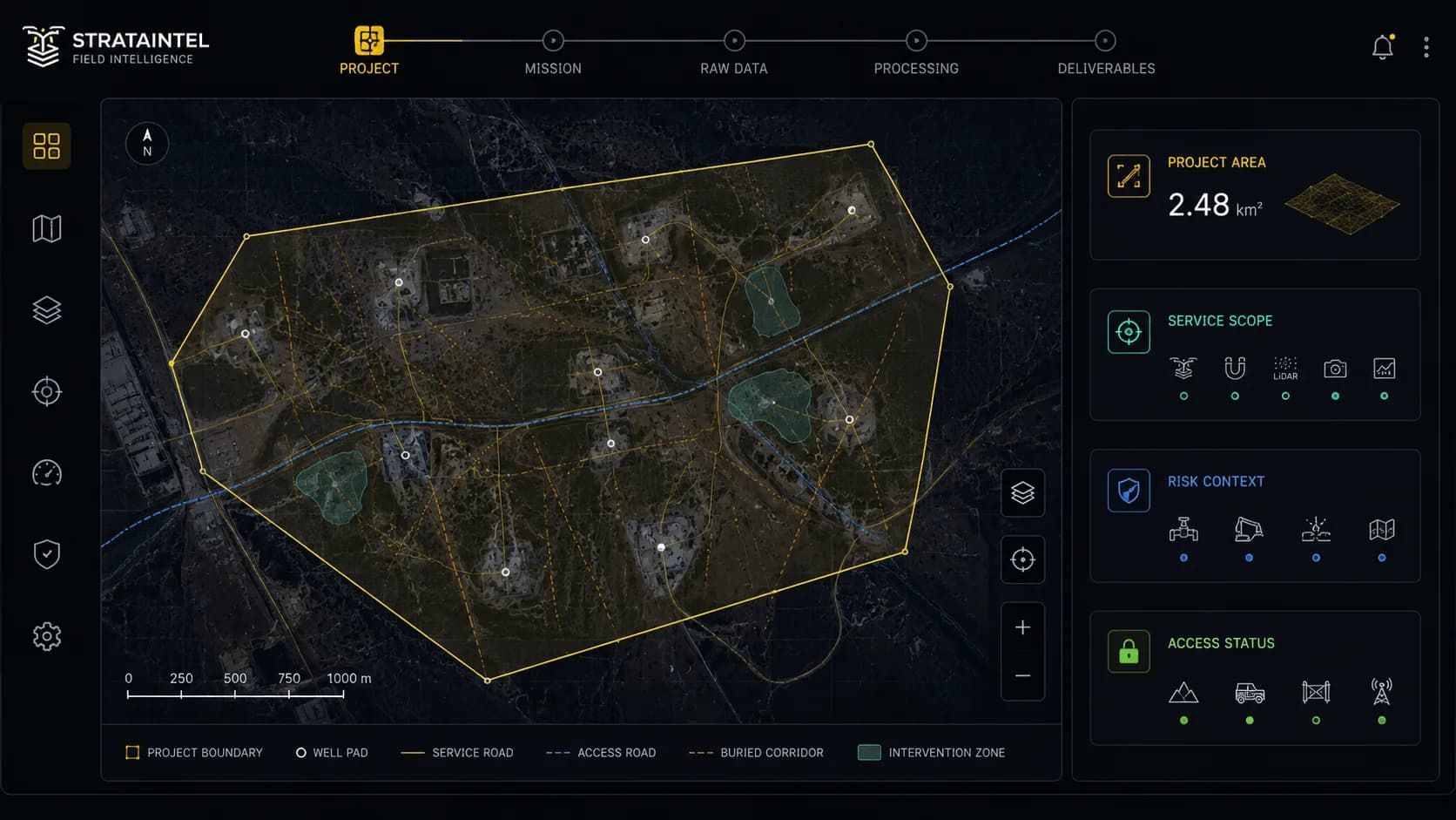
Project Setup
We define the area of interest, operational context, access requirements, and risk hypothesis before any field acquisition begins.
The Problem
Oilfield operations often depend on incomplete field information.
Mature oilfields carry decades of operational history. Buried pipelines, abandoned metallic infrastructure, undocumented crossings, casing remnants, and out-of-service assets may remain underground long after original records become outdated or incomplete.
Accidental damage to buried pipelines or metallic infrastructure
Delays caused by unexpected underground obstructions
Increased environmental and safety exposure
Cost overruns from incomplete field documentation
Higher risk during well pad expansion, trenching, or civil works
Poor visibility before contractor mobilization
Flagship Capability: Aerial Magnetometry for Buried Infrastructure Detection
Aerial magnetometry uses a high-sensitivity magnetometer mounted on an industrial drone platform to measure variations in the Earth's magnetic field. These variations can reveal the presence of buried ferromagnetic objects such as pipelines, metallic debris, abandoned infrastructure, casing remnants, and other undocumented subsurface assets.
What it helps detect
- Buried pipelines and metallic line segments
- Abandoned or undocumented infrastructure
- Ferrous debris and metallic obstructions
- Casing remnants and well-related metallic assets
- Potential conflict zones before excavation or construction
Typical outputs
The exact deliverable format depends on project scope, sensor configuration, processing requirements, and client needs. Final output formats should be defined during the technical scoping phase.
- Magnetic anomaly maps
- Risk or priority zones for further review
- Field intervention support maps
- Technical survey summaries or reports
- GIS-compatible data layers, when required
Use Cases
Built for high-consequence field decisions.
Pre-Excavation Risk Assessment
Identify buried metallic infrastructure and anomaly zones before trenching, excavation, or civil works begin.
Well Pad Expansion Planning
Support planning around existing pads, buried flowlines, undocumented crossings, and mature field infrastructure.
Pipeline and Flowline Route Verification
Validate suspected buried line paths and detect potential deviations from historical drawings or incomplete records.
Abandoned Infrastructure Detection
Locate metallic remnants from previous operations that may affect new construction, maintenance, or rehabilitation work.
Contractor Pre-Mobilization Intelligence
Give contractors better field visibility before committing equipment, labor, and execution schedules.
Environmental and Operational Risk Reduction
Reduce the probability of accidental contact with buried assets that could create spills, downtime, or safety incidents.
Operating Environment
Designed for mature and complex oilfield environments.
StrataIntel is being developed for oilfield environments where operational history, buried infrastructure, and incomplete documentation create uncertainty before field intervention.
Mature Fields
Decades of buried infrastructure and historical operational layers.
Heavy-Crude Operations
Complex surface and subsurface layouts requiring better field visibility.
Well Pads and Flowlines
Field layouts with buried corridors, crossings, and service infrastructure.
Rehabilitation Zones
Areas where historical records do not fully match current field reality.
Data Custody
Field data requires structure, custody, and control.
Industrial field data is sensitive. StrataIntel is being designed around a structured internal data workflow that controls how project information moves from field acquisition to processing and final delivery.
Structured Records
Project, mission, and data records organized from the start.
Controlled Storage
Raw and processed data handled through defined custody workflows.
Access Management
Role-based access, processing handoffs, and deliverable version control.
Audit Trails
Workflow events and data access activity can be tracked for internal control.
Ownership Rules
Project-specific data ownership and retention logic can be defined.
Professional Delivery
Final outputs organized for planning, review, and contractor coordination.
Packaged Capabilities
Packaged field intelligence, built around the mission.
Aerial magnetometry is the flagship capability, but many field decisions require more than one data layer. Depending on project needs, StrataIntel may combine magnetometry with additional sensing and field-data acquisition methods to support broader operational planning.
Detection of buried metallic infrastructure, abandoned assets, ferrous debris, and magnetic anomaly zones.
High-resolution elevation and surface modeling for infrastructure planning, terrain analysis, drainage context, and digital field representation.
Aerial sensing support for identifying potential methane emission zones and strengthening environmental monitoring programs.
Thermal imaging for selected industrial inspection use cases, including heat anomalies, equipment monitoring, and asset condition review.
Visual mapping and orthomosaic generation for site documentation, planning, and field reference.
Project-to-deliverable structure for storing, tracking, processing, and delivering technical outputs.
Operational Note: Developed for formal industrial deployment.
StrataIntel is being structured as a technical-industrial service model subject to applicable aviation, importation, operational, and data-related requirements.
Important distinction: The service is not recreational drone operation, audiovisual production, public surveillance, or security monitoring. It is industrial field-data acquisition for infrastructure and operational planning.
Service Documentation
Download our service documentation.
Access technical documentation covering our industrial drone capabilities, service scope, and operational context.
Resources
Field intelligence articles for teams working in mature oilfields.
Read practical pieces on buried infrastructure risk, field uncertainty, and the data workflows that improve decisions before work starts.
LiDAR, photogrammetry, and magnetometry: when to use each technology in the field
These technologies do not compete with each other. They answer different questions about surface visibility, terrain geometry, and buried metallic infrastructure. The right choice starts with the decision, not the drone.
Built for real field decisions
These resources are written for operators, EPC teams, contractors, and maintenance leaders who need to align planning with site reality before execution begins.
First published article
LiDAR, photogrammetry, and magnetometry: when to use each technology in the field
A practical guide to choosing between LiDAR, photogrammetry, and aerial magnetometry based on the operational question teams need to answer before acting in the field.
Ready to talk?
Book a 30-minute call to discuss your field operations and how StrataIntel can help reduce uncertainty before your next intervention.
Book a Call